About the Callicoma Walk

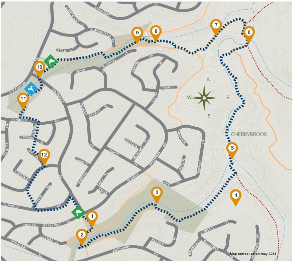
The Callicoma Walk is a spectacular trail that wanders through bushland, parkland and quiet residential streets. Experience a range of environments including lush forest, sandstone woodland, and relaxing lakeside picnic areas.

icon
Location
Cherrybrook
icon
Length
5.1km. Allow 3 hrs.
icon
Difficulty
Grade 3 (moderate)
icon
Start/End Points
Corner of Francis Greenway Drive and Macquarie Drive
icon
Car Zone
icon
Bus Zone
Travel by Public Transport: (M60) from Pennant Hills Railway Station
icon
Toilet Zone
Edward Bennett Reserve, Edward Bennett Drive, Cherrybrook (24 hours); Erlestoke Park, Erlestoke Street, Cherrybrook (24 hours)
icon
Drinking Water Zone
Lakes of Cherrybrook

facilities

icon Shopping
icon Picnic shelters
icon
Creeks
icon
Callicoma Walk
icon
Contour interval 2m
icon
Points of interest
icon
Roads
icon
Fire Trail
icon
Bushland
icon
Other tracks
icon
Drinking water
icon Points of Interest

Some of the trees here are giants: Blackbutt (Eucalyptus pilularis) with its rough grey lower trunk (remaining black long after fires) and smooth white or cream upper trunk and branches; and Sydney Red Gum (Angophora costata) with smooth pink or orange bark and distinctive contorted limbs. Old trees such as these contain hollows which provide vital nesting sites for many native birds, mammals and insects.

The track crosses Nyrippin Creek on raised concrete stepping cylinders just upstream from a pretty cascade. Notice how the vegetation changes from being relatively dry and open on the slopes to more closed and moist along the creek. There is a good view downstream of the shady temperate rainforest.

A small side track leads down to a peaceful spot on a bend in Nyrippin Creek. The area is totally surrounded by Coachwoods (Ceratopetalum apetalum). Notice their characteristic smooth trunk, thin horizontal rings and white lichen blotches. The highly prized timber of this tree is light, easily worked and has a ‘caramel’ odour. As the name suggests, it was used in colonial times for coach building, Mosquito Fighter Bomber frames and 303 rifle stocks during the Second World War.

This spectacular area with its high vantage point and sculpted sandstone overhangs features Hawkesbury Sandstone, and underlies much of the Sydney region. Feel the sand and quartz grains laid down around 200 million years ago, when Sydney was a vast floodplain and dinosaurs roamed the earth. When sandstone weathers, it produces a shallow, sandy, infertile soil that is unable to retain much moisture. To survive these difficult conditions some plants have tough, thin leaves and small or woody fruit. Look for the flower spike of the Grass Tree (Xanthorrhoea spp.), the grape-like fruit of the Geebung (Persoonia spp.) and the woody ‘cone’ of the Banksia (Banksia spp.).

This point marks the junction of Nyrippin and Berowra Creeks. Though we are deep in the bush you may still see the impacts of the urban areas upstream. Rainwater hitting the roads, rooves, and other hard surfaces has no opportunity to soak into the ground. Instead, it is funnelled into gutters and drains along with rubbish and pollutants and sent into the bushland creeks.

Nyrippin is reputed to be a non-local Aboriginal word meaning "to clean" or "to wash".

The Jungo is a colloquial version of ‘junction’. Where Berowra Creek meets Zig Zag Creek, our trail joins the Great North Walk. There is some suggestion the area was once used as a campsite by Aborigines. Up until 1940s local kids swam in the creeks until they began contracting infections from the water. This may have been due to the poultry farms and flour mills that were located upstream in West Pennant Hills, and the slaughter yard that was located up Zig Zag Creek in Thornleigh.

As you climb the ridge, keep an eye out for the Narrow-leaved Apple (Angophora bakeri). Related to the giant Sydney Red Gum seen earlier, this species is a much smaller tree (up to 10m) with grey fibrous bark on trunk and branches and fine drooping leaves. Though they may look similar to Eucalypts, Angophoras belong to a different group.

This sediment basin was constructed by Hornsby Shire Council in 2007. Devices such as these are an attempt to mitigate the effects of stormwater on the bushland. The aim is for the water exiting the device to be cleaner than that entering.

This area was previously a construction site for the installation of sewer lines in the area. Since being obtained by Hornsby Shire Council in 2004, the weedy area was capped with 500 tonnes of sterile crushed sandstone. In 2010, 1400 local natives were planted. One section near McKinley Place was instead spread with top soil from a nearby development site. The native seeds in the top soil have since germinated, resulting in a much more diverse natural array of species in than in the planted zone.

Back when Cherrybrook was part of the rural district, this chain of ponds was created through the damming of the creek for the benefit of farmers. Today it forms an attractive picnic and recreation area, home to native and introduced ducks, Little Pied Cormorants (Microcarbo melanoleucos), Swamphens (Porphyrio spp.) and Kingfishers.

The Lakes are surrounded by remnant Blue Gum High Forest, an extremely rare ecological community with less than 5% of its original distribution left in existence. It is characterised by the majestic Sydney Blue Gum (Eucalyptus saligna), though also contains Red Mahogany (Eucalyptus resinifera), and Turpentine (Syncarpia glomulifera). Over 50 species of indigenous plants have been identified in this small patch alone.

The Lakes are surrounded by remnant Blue Gum High Forest, an extremely rare ecological community with less than 5% of its original distribution left in existence. It is characterised by the majestic Sydney Blue Gum (Eucalyptus saligna), though also contains Red Mahogany (Eucalyptus resinifera),and Turpentine (Syncarpia glomulifera). Over 50 species of indigenous plants have been identified in this small patch alone.

Due to areas of limited mobile coverage, remember to download this map (PDF) before you begin walking.