About the Terrys Creek Walk

Explore a beautiful pocket of rare unspoiled bushland right next door to suburbia with the Terrys Creek Walk. An important waterway that flows into the Lane Cove River, Terrys Creek was named after the first mayor of Eastwood, Edward Terry.

icon
Location
Epping
icon
Length
1.5km Essex Street to Pembroke Street approx 30 mins, 1.5km from Essex Street to the Cascade (Point of Interest number 7) approx 30 mins, or 7 km for Abuklea Road to Browns Waterhole approx 3hrs
icon
Difficulty
Grade 2 (easy/moderate)
icon
Start/End Points
Vimiera Park (cnr Albuera Road and Essex Street, Epping) or Abuklea Road, Epping
icon
Car Zone
icon
Train Zone
20min walk from Eastwood and Epping Station via Pembroke Street, Essex Street, Abuklea Road and Stanley Road
icon
Bus Zone
Travel by Public Transport: 551 from Eastwood Station
icon
Creeks
icon
Terrys Creek Walk
icon
Browns Waterhole Track
icon
Points of interest
icon
Start/end points
icon
Roads
icon
Bushland
icon
Drinking water
icon Points of Interest

In the 1830s, the first road connecting the colony of Sydney to settlements in the Hunter Valley ran past this point. It is said that the grassed area of Vimiera Park was used by travellers journeying north on their first night out of Sydney. The abutments of a convict built bridge across the creek can still be seen on the left of the trail as a raised mound.

This area, called Vimiera Park, contains remnant Blue Gum High Forest, an extremely rare ecological community with less than 5% left in existence. It features the majestic Sydney Blue Gum (Eucalyptus saligna), though also contains Blackbutt (E. pilularis), and Turpentine (Syncarpia glomulifera). Blue Gums are obvious by their bluish smooth trunk and ‘sock’ of rough bark at the base. Blackbutts have a rough bark ‘stocking’ on the trunk up to the lower branches while the Turpentine is rough barked with fruits resembling spaceships.

Eastern water dragons (Intellagama lesueurii lesueurii) are lizards found around Terrys Creek basking on rocks, darting off the track or diving and swimming in the creek. They grow up to 90cm long and their tails make up two-thirds of their body length. With long, powerful limbs and claws for climbing, a long muscular tail for swimming and a spiky crest down their body, they add a prehistoric element to this walk.

Grey myrtle (Backhousia myrtifolia) rainforest promotes the growth of mosses and lichens. There is also evidence that this area was once a sandstone quarry. Vertical drill marks can be seen on rock faces and chunks of blasted stone lie in the creek. Perhaps the stone was used in the construction of the Great North Road.

The large trees with smooth pink or orange trunks and dimples are known as Sydney Red Gums (Angophora costata), some aged over 200 years old. Closely related to the eucalyptus, they are very important habitat for many birds especially parrots and owls, possums and bats, which use their hollows for shelter and nesting. Can you see any hollows being occupied at present?

Despite much of the vegetation along the banks of Terrys Creek being dominated by weeds, this section of creek remains relatively healthy. Coachwood (Ceratopetulum apetulum) has a smooth trunk, thin horizontal rings and white lichen blotches. The highly prized timber of this tree is light, easily worked and has a caramel odour. Used in colonial times for coach building and later for Mosquito Fighter Bomber frames and 303 rifle stocks during the Second World War. Also growing along the creek is the Water Gum (Tristaniopsis laurina). The trunks and branches of this species are shaped in the direction of the water flow.

This pool below the lovely cascade was once a favourite swimming hole before urban pollution made swimming here unsafe. Nevertheless, there have been sightings of eels and Eastern long-necked turtles (Chelodina longicollis). Much of the litter that accumulates here comes from streets, so remember to dispose of rubbish responsibly!

The soft, broad leaved plants give way to shrubby species typical of sandstone derived soil. The shallow, sandy, infertile soil is unable to retain much moisture. To survive these difficult conditions some plants have tough, thin leaves and small or woody fruit. Look for the flower spike of the Grass Tree (Xanthorrhoea species), the grape-like fruit of the Geebung (Persoonia pinifolia) and the woody ‘cone’ or the Banksia (Banksia spinulosa).

According to local lore, there was a dam that served as the local swimming pool. In 1954 local landholder John Dence sold the land to Council. Some of Stanley Road was subdivided for residential development, and the rest became a park named in his honour. Six years later, Epping Aquatic Centre was built on the site.

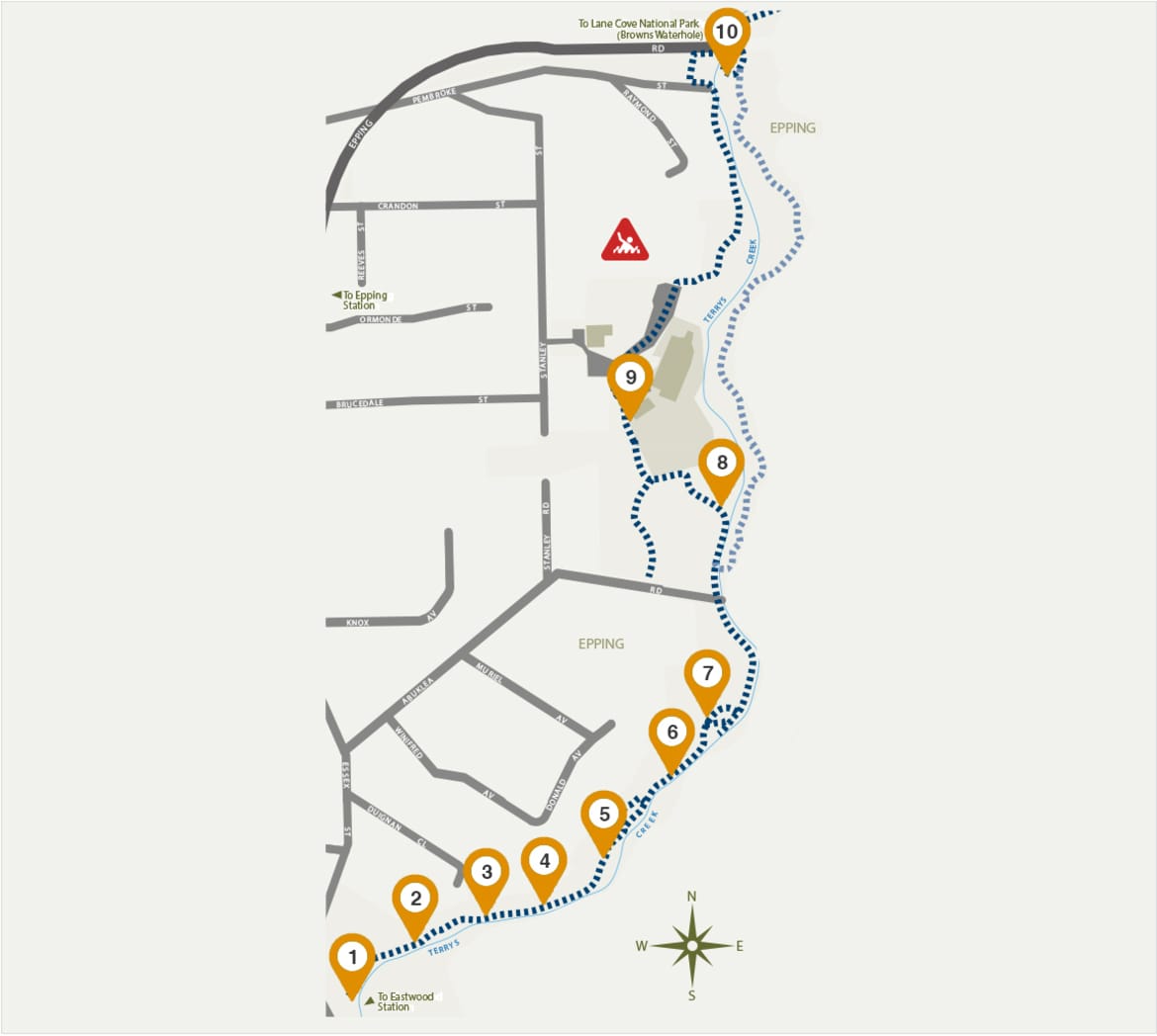
Before Terrys Creek bridge was built in 1939, travellers would come down Pembroke Street, wade across the creek via a weir then wind their way up the steep slope on the other side. The Terrys Creek Bridge is listed on the New South Wales state heritage inventory as it forms an important component of Epping Road, allowing for the patterns of development of the northern and north western sector of Sydney.

A short stroll up Pembroke Street is a path to the bridge. By crossing the bridge then walking under it, the trail continues on the east of Terrys Creek to Lane Cove National Park for approximately 5.5km to Browns Waterhole. A trail on the eastern side of Terrys Creek joins the trail near the end of Abuklea Road.

Due to areas of limited mobile coverage, remember to download this map (PDF) before you begin walking.